What is Thames Water's Teddington Direct River Abstraction?

The Thames Water TDRA scheme proposes:

  • To build a new abstraction (water removal) facility on the Ham Lands riverside above Teddington Weir (see images)
  • To use this abstraction facility to abstract (remove) millions of litres of water from the River Thames and send that water to the Lea Valley Reservoir
  • To build a new discharge facility also on the Ham Lands riverside (see images)
  • To use this discharge facility to pump millions of litres of treated sewage into the River Thames at Teddington
  • Note: It remains unclear if this 24x7x365 treated sewage output would all be placed into the Thames at Teddington. Some or all of it could go down the existing Mogden sewage treatment pipe that deposits into the tidal Thames at Isleworth Ait.
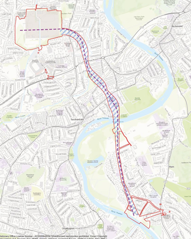
  • To pipe-jack a 4.5-kilometre tunnel under the streets of Isleworth, Twickenham, Teddington, Ham and Kingston. This tunnel will go from Mogden Sewage Works, under private residences as well as parks, under the river, and onward through Ham Lands to Burnel Open Space. (See the tunnel route map)
  • To destroy natural land in St Margaret’s (Moormead Park), Ham and North Kingston to build eight shafts to access the tunnel (see images)
  • To build a connection to the nearby and existing Thames Lee Tunnel to convey abstracted water to the Lea Valley reservoirs for use in East London

To read more about this scheme in Thames Water's words, see their website here.

Why is Thames Water proposing TDRA?

  • This scheme is proposed as a ‘drought resilience project’
  • The goal is to provide up to 75mlpd (million litres/day) of drinking water in times of prolonged drought only.

How often will TDRA scheme operate?

  • This scheme is called a 'contingency' asset. Thames Water claims it will not be operational daily.
  • Thus, it is planned to operate every 2 to 3 years and then almost entirely between July and November over their current 47-year outlook plan to 2075
  • However, while it is proposed as a contingency asset, to be used only during drought periods, the discharge of treated sewage will actually operate continually at up to 25% of full (77 mlpd) capacity 24x7x365 to ensure the mechanical systems and filters are kept operational. This is called a "sweetening flow."

When will TDRA be operational?

Plans are progressing now. In December 2023, Thames Water accelerated plans by officially bypassing local planning authority to fast track the scheme.

Without action, this plan will go ahead.

Join us to fight it! We need you!

Treated Effluent Tunnel and Shafts — Thames Water's Preferred Route

A map of Thames Water's preferred locations for the tunnel, shafts and facilities in the TDRA (Teddington Direct River Abstraction) scheme.

The map is based on Thames Water's documents in their Documents Library (expand Consultation documents and go to Map Book). The original map provided by Thames Water is here.

The Shafts

Creating the pipeline tunnel requires seven 10.5m diameter shafts along its route. The first shaft is at Mogden Sewage Works, and the last is near the discharge location on Burnell Open Space.

The five intermediate shafts are:

  • Ivybridge (Isleworth)
  • Moormeads Recreation Ground (Twickenham)
  • Hamlands North (Richmond)
  • Hamlands West (Richmond), and
  • Burnell Open Space (North Kingston).

Each shaft will require a construction compound of up to 2,500 square metres. (About 12 standard tennis courts side-by-side.). During the construction of these shafts, land will be inaccessible to public use. The shaft sites will be active construction areas for up to 8 months each. Each shaft may need 26 HGVs (Heavy Goods Vehicles) daily (averaged over the 8-month period). There may be 24-hour working for some of the tunnelling.

The North Kingston (Burnell Open Space) site will be active for at least 21 months. This is because the North Kingston site will be the site of construction of the discharge and abstraction facilities.

Once complete, each shaft location will have an area of about 10.5m capped with a concrete cover. That shaft concrete cover would be permanent just below the ground surface. There would be two ground surface access covers measuring approximately 2m x 2m each (4m squared) for access. All shafts must be accessible to Thames Water for maintenance so that land use can never change.

A typical building site for lowering shafts. The shaft sites will be active construction areas for 6 – 8 months each. (Image from Sennebogen.)

Another typical building site for lowering shafts. (Image from Donnegan Civil Engineering on a project for Scottish Water.)

Shaft 1: Ivy Bridge Retail Park

The proposed shaft 1 construction site will be located at the north end of the Ivybridge Retail Park car park in Isleworth.

Shaft 2: Moormead Park

Moormead Park Shaft site
Moor Mead Park cropped

The proposed shaft 2 construction site will be located in the centre of Moormead Park. Construction will take up to two years and require an access road to Hill View Road, the upgrading of Hill View Road to accommodate HGVs, and the creation of a temporary road for access. Moormead Park is used every day by the community.

Shaft 3: Ham Street Car Park for Ham House

Ham Car Park Shaft site
Ham Street Car Park for Ham House

The proposed shaft 3 construction site is located in Ham Street car park, a free car park used by visitors to Ham House, Ham Lands Nature Reserve and the Thames Path national trail, which runs alongside the river here.

Shaft 4: Riverside Drive Playground

Shaft 4 location Riversite Playground
Riverside Drive in Ham

The proposed shaft 4 construction site location next to Riverside playground. On the edge of Ham Lands local nature reserve, Riverside Drive children's playground, Ham Street Allotments and Richmond and Kew Football Club. Works here would require HGVs passing in front of Grey Court School down the narrow Ham Street.

Shaft 6: Ham Lands by Riverside Drive

Shaft 6 location Ham Lands, Riverside Drive
RIVERSIDE

The proposed shaft 6 construction site is on Ham Lands Local Nature Reserve.  This area is a regular route for the Richmond Half Marathon and other sports activities.

(Note: shaft 5 was removed from plans.)

The abstraction facility

A new abstraction facility will be built on the towpath of Burnell open space, and a new abstracted water pipeline shaft will be built a short distance away. The abstraction facility is likely to measure approximately 38m long and 3m to 4m in height above normal water level. The intake structure could be partially set into the riverbank and extend into the river by up to 3m. Thames Water indicates it will take 21 months to build this abstraction facility. The abstracted water would be removed to Lee Valley reservoirs in north London. Thames Water has said this will only be during periods of drought. In periods of drought, the river will be at its most stressed, and the possibility of ecological harm is everpresent.

The abstracted water pipeline and shafts — Thames Water's options

A pipeline is required to take the abstracted water from the abstraction facility to the existing Thames Lee Tunnel (TLT). Two shafts are required for the abstracted water pipeline.

The first will be near the abstraction facility in Burnell Open Space. The second will be a Thames Lee Tunnel (TLT) connection.

There are two options for the TLT connection:

  • Park Gate woods (destroying areas of trees and wildlife habitat) or
  • Tudor Drive junction (where there is a "pocket park").

A pipejacked tunnel under Royal Gate Park Estate would be needed for the Tudor Drive option. It is not known what kind of pipeline works would be used for the Royal Park Gate woods option.

Burnell Site Abstraction

Location of the Burnell Avenue abstraction and outfall facilities.

TDRAAbstraction Location 2048

The photo shows the location of the proposed abstraction facility along the River Thames.

indicative image of abstraction structure

Thames Water has provided the image below to indicate what the abstraction facility will look like. This will be built on the Thames River Path in Teddington.

The abstraction / intake facility at Bessborough Walton Upon Thames, to show what we might expect at Teddington. (Click for larger photo.) See below for more real-life abstraction facilities.

Abstraction facility at Bessborough in Walton Upon Thames.

Abstraction facility at Bessborough in Walton Upon Thames.

Abstraction facility at Bessborough in Walton Upon Thames.

The abstraction / intake facility at Surbiton, taken from the river, to show what we might expect at Teddington.

The abstraction / intake facility at Bessborough Walton Upon Thames, to show what we might expect at Teddington.

The outfall (discharge) structure

The Discharge facility will be built on the riverside of Burnell Open Space. The last pipeline shaft will be built a short distance away in the Open Space. In a drought, millions of litres of treated sewage will be pumped into the river from the discharge facility, with a significant ecological impact on the river.

indicative image outfall facility

Thames Water has provided this image to indicate what the outfall (discharge) structure will look like. This will be built on the Thames River Path in Teddington.

Hogsmill STW Outfall

What an outfall (discharge) structure looks like in real life - this one at Hogsmill.

bluetits at abstraction point

The Blue Tit swimmers in the River Thames, near where the TDRA outfall (discharge) structure will be located in Teddington. (Photo courtesy of D Gwilliam)

Location of the discharge site along the riverside